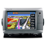


GPSMAP 740 is a stand-alone touchscreen chartplotter that brings a new level of functionality to your vessel. Featuring a brilliant 7" (17.78 cm) display, GPSMAP 740 puts all the information you need right at your fingertips. GPSMAP 740 is preloaded with U.S. coastal maps. In addition, GPSMAP 740 accepts radar input and offers full NMEA 2000® connectivity for greater convenience when adding extra sensors.
Explore the Seas
GPSMAP 740 contains preloaded map data for all U.S. coastal areas, including Alaska and Hawaii, plus Explorer Charts for the Bahamas. GPSMAP 740 also features an internal, high-sensitivity GPS receiver for superior satellite tracking and quicker acquisition times. And as an added benefit, GPSMAP 740 can receive graphical weather data for North America through the optionalGXM™ 51satellite receiver/antenna (sold separately).
Take Control by Touch
Input is easy with GPSMAP 740. Whether you’re changing course or simply reviewing information in front of you, the intuitive touchscreen interface makes for simple operation. The device also offers flexible brightness levels for daytime readability along with low-light dimming during night use. And with a widescreen display that’s rugged and waterproof, it’s made to perform in any situation.
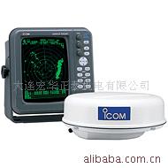
Expand with Radar
Featuring a built-in radar port, GPSMAP 740 can be interfaced with Garmin’s line of affordableGMR™ marine radar systems(sold separately). Whether you’re adding radar now or in the future, you’ll enjoy the convenience of “plug-and-play installation” as well as the power, range and high-definition targeting of our proven radar offerings.¹
Add Extras with BlueChart g2 Vision
With the optionalBlueChart g2 VisionSD™ card, you can add a whole new dimension of exceptional features to your chartplotter.
- MarinerEye view and FishEye view provide you a 3-D perspective of map information, both above and below the waterline.
- High-resolution satellite images and aerial photographs help you orient yourself in unfamiliar areas.
- Auto Guidance technology searches through all relevant charts to create a route you can actually follow — one that avoids obstacles, shallow water, buoys and other obstructions.
¹Garmin Marine Network not supported.
²Depth capacity is dependent on water salinity, bottom type and other water conditions (with 1 kW transducer).
硬件和性能: | |
| 尺寸,長x寬x高: | 8.8" x 5.6" x 3.1" (22.4 x 14.2 x 7.9 cm) |
| 顯示屏尺寸,長x寬: | 6.0" x 3.6", 7.0" diagonal (15.2 x 9.1 cm, 17.8 cm diagonal) |
| 分辨率,長x寬: | 800 x 480 pixels |
| 顯示類型: | WVGA display |
| 重量: | 2.48 lb (1.1 kg) |
| 電池: | none |
| 電池使用時間: | none |
| 防水: | 是(IPX7) |
| 高靈敏度接收機: | 有 |
| 天線: | internal |
| NMEA輸入/輸出: | NMEA 0183 compatible and NMEA 2000® certified |
| Power consumption: | 0.6A at 12V; 0.3A at 24V 0.8A at 12V; 0.4A at 24V (with sonar) |
地圖和內存: | |
| 電子底圖: | 有 |
| Preloaded maps: | yes (coastal maps) |
| 可附加地圖: | 有 |
| 內存: | none (cannot load maps to internal memory) |
| 支持存儲卡: | SD™ card slot |
| 航點/收藏夾/位置: | 3,000 |
| 航線: | 100 |
| 航跡記錄: | 20,000 points; 50 saved tracks |
特征: | |
| 兼容Garmin雷達: | 有 |
| 兼容Garmin聲納: | 無 |
| 兼容Garmin Marine Network™: | 無 |
| 觸摸屏: | 有 |
| 支持AIS(跟蹤目標船的位置): | 有 |
| 支持DSC(顯示帶有DSC的VHF無線電的位置數據): | 有 |
| 聲音報警: | 有 |
| 潮汐表: | 有 |
| 打獵釣魚日程: | 無 |
| 太陽月亮信息: | 有 |
| 三維地圖視角: | 是(可選BlueChart g2 Vision海圖卡) |
| 自動引導: | 是(可選BlueChart g2 Vision海圖卡) |
| 兼容美國XM WX天氣預報無線電: | 有 |
| 建議路線規劃: | 無 |
| 語音播報(例如,前方500米右轉): | 無 |
| 語音播報路名(例如,前方500米右轉到霄雲路) : | 無 |
| 耳麥/音頻輸出: | 無 |
| 音頻/視訊 輸入/輸出: | 無 |
| 可便攜的: | 無 |
| 適用於汽車/摩托車: | 無 |


批發市場僅提供代購諮詢服務,商品內容為廠商自行維護,若有發現不實、不合適或不正確內容,再請告知我們,查實即會請廠商修改或立即下架,謝謝。